INERTIAL MEASUREMENT UNIT ( IMU05, IMU05-S) - OVERVIEW
High-precision measurements of pitch, roll, and yaw rate using three industry leading gyroscopes, as well as x, y, z acceleration via three accelerometers.
IMU05 is available in two versions. The regular model features three top-tier, highly accurate gyroscopes with a bias stability of 1.2°/hr, whilst the S model measures roll, pitch, and yaw rate using three outstanding MEMS high-precision gyroscopes that maintain a bias stability of just 0.8°/hr.
Both options can be used as a standalone sensor, with easy connectivity and configuration options through the CAN or serial interface or in conjunction with VBOX data loggers, allowing for precise synchronisation to GNSS time.
Data from the IMU can be seamlessly integrated with GNSS data from a VBOX 3i or VBOX 4 to enhance measurement accuracy when GNSS signal reception is interrupted or weakened. Used as an Inertial Navigation System (INS) the IMU05 will produce pitch and roll angles accurate to 0.03° RMS (0.02° RMS for IMU05-S), yaw angles accurate to 0.15° RMS (<0.1° RMS for IMU05-S) and smoother velocity data. This ensures reliable data even when satellite signal reception is compromised.
IMU05-S

IMU05

KEY FEATURES
|
|
IMU Integration
Survey-grade high-speed GNSS is the most accurate way to measure velocity - as long as view to the sky is clear.
Problems arise when buildings or tall trees obstruct the testing ground. If the GNSS signal is interrupted, dropouts cause spikes in data, which is not ideal when you are relying on a clean velocity signal.
In order to keep high GNSS accuracy even where sky visibility is less than perfect, Racelogic couples data from an IMU and the VBOX 3i GNSS data logger.
By blending GNSS with data from an Inertial Measurement Unit, housing three gyros and three accelerometers, smoother, more reliable data is produced. The solution can deal with GNSS dropouts, maintaining high accuracy. IMU integration realises the high accuracies that VBOX 3i or VBOX 4 can achieve even when external conditions are compromised, meaning that data has now become more reliable and easier to interpret.

How does IMU Integration improve the GNSS data channels?
Velocity
IMU integration decreases the noise for a more accurate reading, and maintains a precise velocity measurement throughout the GNSS drop outs.
Heading
The heading reading here is very consistent, providing more accurate results than the GNSS only data, which exhibits some noise, even in low speeds.
Position
When mapping vehicle position along a heavily tree lined road, the GNSS signal incurs some drop outs and reflections, producing noisy position readings. However, IMU integration corrects the position measurements, creating smoother, more accurate data.
Acceleration
IMU Integration data provides a smoother, more accurate representation of longitudinal acceleration (measured in G-force) during an ABS brake stop.
Brake Testing using IMU Integration
Conducting brake tests on tall vehicles with long suspension travel can result in a speed overshoot of the velocity data, due to the measurements being taken at the high roof position of the GNSS antenna. As the brakes are initially applied, there is a higher rate of change in velocity at the roof than there is at the vehicle's centre of gravity (COG).
However, the integration of an IMU04 or IMU03 with a suitably upgraded VBOX 3i can be used to counteract this 'lever-arm' effect by placing the IMU at the COG, which measures the vehicle pitch as it brakes. This data, when combined with that from GNSS, provides a compensation for the overshoot and allows for consistent brake stop testing.

Counteracting the lever-arm effect will also aid test engineers when conducting high-dynamic manoeuvres other than brake stops. In slip angle measurements the speed overshoot can occur if the antenna is moving through a greater arc of travel than that of the vehicle's centre of gravity as it corners. Procedures such as lane change manoeuvres can therefore benefit from IMU integration and lever-arm compensation.
The graphs below show how point A has travelled further than point B:

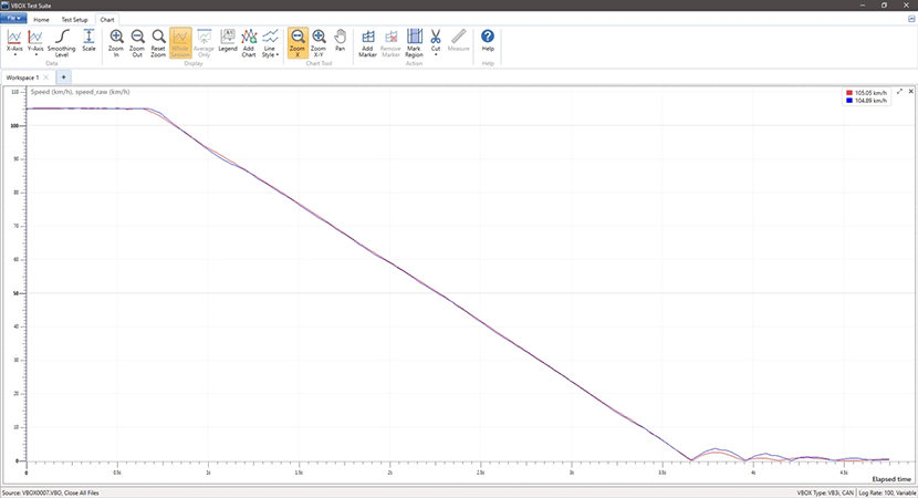
Blue trace = GNSS Speed; Red trace = IMU-corrected data
In this example of a high-dynamic brake stop, the blue trace (GNSS Speed) overshoots at the initial point of brake application, and then exhibits a damped oscillation as the deceleration continues. The IMU-corrected data (red trace) accurately records the brake stop from the vehicles centre of gravity.

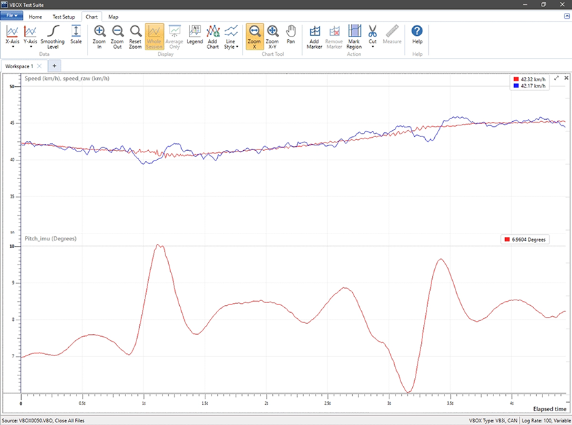
Red (below) = Pitch measured by the IMU; Blue = GNSS speed; Red = IMU integrated GNSS speed
The traces are of a car going over a speed hump. Note how the GNSS speed alters as the vehicle roof moves independently of the COG as it goes over the hump. The integrated speed logs the correct speed of the vehicle.
